Dayr Simʿān; Telanissos Complete
ID: 165
Region/Province: Syria I
Localization
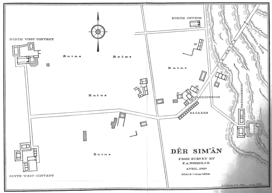
Site plan
Description
Now identified as Dayr Simʿān, the site lies within the Gabal Halaqa massif, approximately 30 km northwest of Aleppo. In antiquity, the location was occupied by Telanissos, an agricultural settlement at a junction of routes, established sometime between the 1st and 4th centuries AD. In the early 5th century, a monastic ensemble arose in the vicinity of the village. The place achieved wide renown through the presence of Saint Simeon Stylites, one of its monks. Simeon is reported to have spent the greater part of his ascetic career in a 20‑metre commune, dedicating himself to prayer and to instructing visiting pilgrims. Numerous healings and conversions were attributed to his activity, drawing large numbers of pilgrims to Telanissos. After Simeon’s death, the village developed into a pilgrimage shrine, a shift that significantly reshaped its urban fabric. Facilities intended for visitors—such as shelters and inns—were introduced. During the 5th and 6th centuries, three additional monastic complexes were erected, commonly designated the North-West, South-West and South-East ensembles. Each comprised a basilica and a pandocheion (pilgrims’ lodging). The principal destination for visitors was the Sanctuary, occupying the former monastery associated with Simeon. Access to this complex was organized along a via sacra that began at the triumphal arch in the urban sector. Plan source: PAES IVB, Pl. V. Further reading: Tchalenko, G., Loosley Leeming, E., 2019. Notes on the Sanctuary of St. Symeon Stylites at Qal‘at Sim‘ān, Leiden. TIB 15 – Todt, K.P., Vest, B.A., 2014. Tabula Imperii Byzantini, vol. 15, Vienna, 1812–1817. Pena, I., Castellana, P., Fernandez, R., 1975. Les Stylites syriens, Milan, 141–149. Tchalenko, G. (ed.), 1953. Villages antiques de la Syrie du Nord: Le Massif du Bélus a l'époque romaine, Paris, vol. 1, 223–276.